No Blind Automation.
GeoAgent Understands, Clarifies, Then Executes.
Most AI tools jump straight to answers. But in GIS workflows, assumptions lead to wrong outputs, rework, and lost time. GeoAgent works differently — it asks before it acts, builds transparent pipelines, and keeps you in control at every step.
Traditional AI tools guess. GeoAgent asks.
- Jump to answers without understanding context
- Make assumptions about your data and intent
- Produce black-box results you cannot verify
- Require manual rework when outputs are wrong
- No way to save or reproduce the analysis
- Asks clarifying questions before execution
- Lets you pick datasets, metrics, and outputs
- Builds transparent, step-by-step workflows
- Every step is editable and customizable
- Save workflows and reuse across projects
From question to complete analysis pipeline
You Ask a Question
Start with a plain-language prompt — no code, no scripts, no SQL. Just describe what you need.
GeoAgent Clarifies
Instead of guessing, GeoAgent asks smart follow-up questions to understand your exact intent — which datasets, what metrics, what output format.
Builds a Transparent Workflow
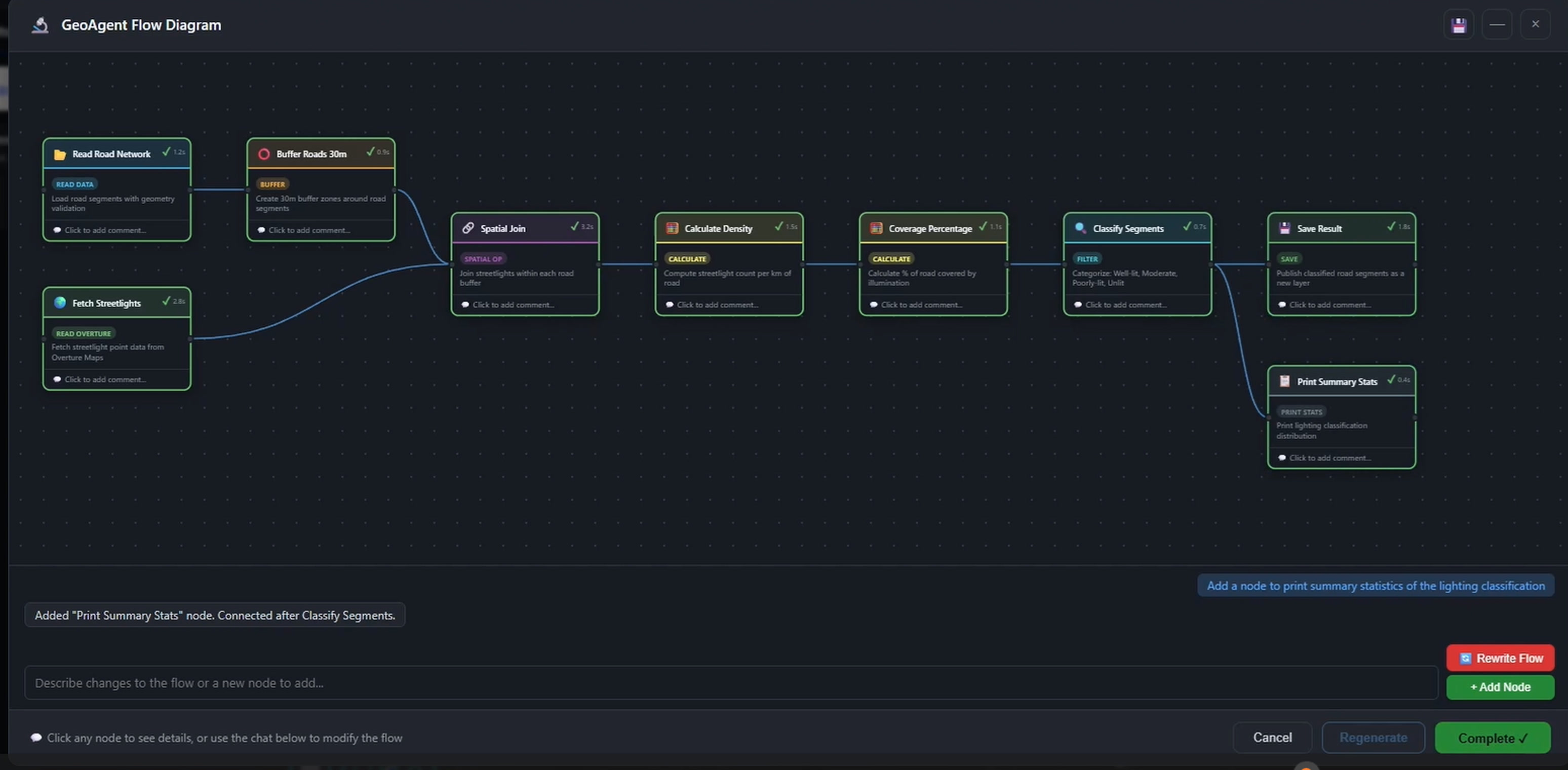
GeoAgent constructs a step-by-step pipeline — data sourcing, spatial joins, calculations, and classification — all visible and explained.
You Customize & Edit
Every step is editable. Change thresholds, swap datasets, adjust classification logic, add new processing steps — you are always in control.
Save, Reuse & Share
Save your workflow as a reusable template. Run it on new data, share it with your team, or schedule it for automatic execution.
One question. Complete analysis.
See how a single plain-language question becomes a full geospatial analysis pipeline.
“Classify road segments based on how well they are lit at night”
Because real-world GIS decisions need control, not assumptions.
Full Transparency
Every step, every calculation, every decision — visible and explained. No hidden logic, no black boxes.
You Stay in Control
GeoAgent proposes, you decide. Edit any step, override any suggestion, customize any output.
Context-Aware Intelligence
GeoAgent understands spatial data types, coordinate systems, and GIS operations — not just text patterns.
Reproducible Pipelines
Every workflow is saved with full provenance. Re-run on new data, audit past analyses, share across teams.
No GIS Expertise Required
Ask questions in plain language. GeoAgent handles the spatial analysis, code generation, and layer publishing.
Multi-Format, Multi-Source
Works across vector, raster, LiDAR, and 3D data. Combine datasets from different sources in a single workflow.
Ready to build GIS workflows that make sense?
See GeoAgent in action. Request a demo and discover how agentic workflows transform your geospatial analysis.
Ready to deploy?
Get a demo, pricing, and a pilot plan tailored to your data stack.