What Can AI Do With GIS Data? 25 Real-World Applications
From crop yield prediction to wildfire forecasting, see 25 real-world ways AI is transforming GIS data - with stats, examples, and use cases.
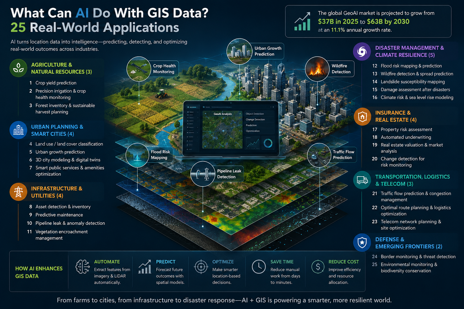
GIS has always been good at answering one question: where. Where is this building? Where does this river flow? Where did the fire start?
AI is changing what happens after that question gets answered. Instead of just showing you a map, it can now tell you what's likely to happen next - and what you might want to do about it.
That shift isn't small. The global geospatial AI market is on track to nearly double by 2030, growing from around $37 billion to roughly $63 billion, as more organizations move from static maps toward systems that spot patterns and forecast outcomes without a human tracing every pixel by hand.
Below are 25 real ways companies and governments are using AI on GIS data right now - not hypotheticals, but production use cases with real numbers behind them.
Quick answer
AI applied to GIS data mostly does three things. It automates the tedious work of pulling features out of imagery - buildings, roads, crops, storm damage - that used to mean someone manually tracing shapes on a screen. It predicts what's coming, whether that's a flood, a wildfire, a crop yield, or a disease outbreak. And it helps organizations make better location-based decisions, from where to open a new store to which power line needs trimming first.
The 25 examples below walk through exactly how, organized by industry.
Table of contents
- What is GeoAI, exactly?
- Agriculture and natural resources
- Urban planning and smart cities
- Infrastructure and utilities
- Disaster management and climate resilience
- Insurance and real estate
- Transportation, logistics, and telecom
- Defense and emerging frontiers
- FAQ
What is GeoAI, exactly?
GeoAI is just shorthand for combining machine learning with geographic information systems. Traditional GIS was mostly about storage and visualization - you fed in data, and it drew you a map. GeoAI goes a step further and actually looks at that data, finding patterns a person would take much longer to spot, or might miss entirely.
A few techniques do most of the heavy lifting. Computer vision handles imagery, picking buildings, crops, or flood damage out of a satellite photo. Point cloud models sort LiDAR data into ground, trees, and structures. Time-series models forecast things like crop yield or flood risk based on what's happened before. And more recently, AI agents have started running entire analysis workflows on their own - usually still with a person checking the output before it's used.
Esri alone now offers more than 100 pretrained GeoAI models through ArcGIS, for tasks that used to take a GIS team days and now take a few hours.
Agriculture and natural resources
1. Crop yield prediction from satellite imagery
Farmers used to wait until harvest to find out how a season actually went. AI is closing that gap.
By tracking vegetation health through satellite imagery across the growing season, models can flag how a crop is doing weeks before it's cut - giving growers time to adjust irrigation or fertilizer instead of just watching a bad outcome unfold. In Senegal, one project applied this across all fourteen departments and cut maize yield prediction error by 59% compared to relying on local data alone. A second, simpler model built entirely on free satellite imagery kept sorghum error under 25%, with no ground surveys at all.
Some newer versions go a step further, producing yield estimates for individual sections of a field instead of one number for the whole thing.
2. Precision irrigation and crop health monitoring
Not every part of a field needs the same water or fertilizer, but until recently there wasn't a cheap way to tell which parts needed what. Drone and satellite vegetation indices change that - they can catch water stress or early disease symptoms in specific zones, well before anything is visible to the eye on the ground.
This is what powers tools like the FAO's WaPOR platform, which tracks agricultural water use from space. For a grower, the payoff is simple: treat the field as a set of zones instead of one big block, and spend less doing it.
3. Forest inventory and sustainable harvest planning
Finland's forestry sector has a labor problem - not enough people to walk every stand of trees and assess it by hand. AI is helping fill that gap.
By combining aerial imagery with weather data, these systems estimate inventory levels and flag where maintenance is needed, so managers can plan harvest cycles and allocate crews more efficiently. It's the same computer vision used to classify crops in a field, just pointed at tree species and biomass instead.
Urban planning and smart cities
4. Automated land use and land cover classification
This is one of the oldest and most widely used GeoAI applications, and for good reason - it saves an enormous amount of manual work.
Instead of a GIS analyst tracing buildings, roads, and water bodies by hand, a trained model can scan a satellite image and label all of it automatically. This pixel is a building. This one's forest. This one's cropland. Platforms like Google Earth Engine now run this kind of classification at a global scale, something that would have been unthinkable to do manually not that long ago.
5. 3D city modeling and urban digital twins
Building a realistic 3D model of an entire city used to be slow, expensive work - flying planes, stitching photos together, modeling structures one by one. AI has cut a lot of that time out.
Point cloud segmentation and photogrammetry now generate lightweight 3D models straight from aerial imagery, with buildings, roads, and vegetation already labeled. Feed that into live data streams - traffic sensors, energy meters, weather feeds - and you get an urban digital twin: a virtual copy of the city that planners can test decisions against before making them for real. Singapore's Virtual Singapore and Helsinki's Helsinki 3D+ are the two most cited examples, and this isn't a niche corner of the market either. Urban planning and digital twins are forecast to be the fastest-growing GeoAI application through 2030, at nearly 13% annual growth.
6. Urban growth forecasting
Cities don't grow randomly. Past sprawl patterns, population trends, and existing infrastructure all shape where new development goes next, and that's exactly the kind of pattern predictive models are good at picking up on.
Planners use this to estimate what a city's footprint will look like in 10 or 20 years, which then feeds into zoning and transit decisions long before actual demand shows up.
7. Tree canopy mapping for urban heat mitigation
Chattanooga, Tennessee is a good example of what this looks like when it actually works. Geospatial AI mapped 5.3 million individual trees across the city at 97% accuracy, then cross-referenced that against thermal imagery to find neighborhoods running more than 20°F hotter than tree-covered areas nearby.
That analysis directed $6 million in federal grant money to exactly the spots where new tree cover would cool the most people per dollar spent. It's a useful reminder that this kind of work needs real spatial data underneath it - not just a general AI model guessing from text.
Infrastructure and utilities
8. LiDAR-based building and infrastructure extraction
Airborne LiDAR produces an overwhelming amount of raw data - millions of individual points with no labels attached. Deep learning models now sort through that automatically, classifying each point as ground, vegetation, a building, or infrastructure, with the best models topping 95% accuracy on standard benchmarks.
That capability is starting to feed directly into construction workflows, too. One production pipeline converts raw point clouds into structured, Revit-ready building models with 70–80% of the work automated. Floors and walls score especially well, above 90% accuracy in places, while smaller details like doors are harder and still need manual cleanup.
9. Road and pavement condition monitoring
Germany's Bavarian State Ministry of Housing, Building, and Transport ran a pilot on one of its major highways that says a lot about where infrastructure maintenance is headed. Instead of waiting for potholes to show up, an AI system analyzes road-surface imagery and flags early signs of wear - sections likely to need repair before they actually fail.
That's a meaningful shift from reactive to predictive maintenance, and it means budget gets spent on prevention rather than emergency fixes.
10. Utility vegetation management and powerline risk detection
Trimming trees away from power lines sounds mundane, but it's a $6–8 billion annual expense for utilities in the US alone - and it's one of the clearest wins AI has delivered in GIS so far.
By combining vegetation-density readings from satellite imagery with GIS buffer zones drawn around transmission corridors, utilities can spot risky growth without sending a crew to look. Some have cut inspection costs by up to 90% this way. One case study found a 51% drop in mechanical trimming costs per acre after switching from a fixed schedule to a risk-based one. Companies like AiDash and LiveEO now handle most of this from satellite data alone, saving drone flights for the spots that actually need a closer look. The broader vegetation management market is projected to pass $52 billion by 2035, and AI-driven monitoring is a big part of why.
11. Grid and utility asset inspection
Corrosion, cracked insulators, leaning poles - small problems that eventually cause big outages - are exactly what computer vision is good at catching early. Trained on drone and satellite imagery, these models can flag dozens of fault types at over 85% precision, and every finding gets geolocated straight into a digital twin of the grid.
That means crews can prioritize repairs by actual risk instead of working through a fixed inspection calendar.
Disaster management and climate resilience
12. Flood risk prediction and mapping
Flood models used to lean heavily on historical flood maps, which go stale fast as land use changes around them. AI models now combine rainfall history, elevation data, soil type, and land cover to estimate flood risk for a given rainfall scenario, before the water shows up rather than after.
Insurers use this to price flood risk more accurately. Cities use it to prioritize drainage investment where it will actually help.
13. Wildfire detection, spread forecasting, and early warning
Wildfire response touches almost every part of GeoAI. Object detection models scan satellite and infrared imagery for smoke and heat signatures to catch ignitions early, while spread models - updated continuously as new observations come in - forecast where a fire is headed next to guide evacuations and resource deployment.
Google's FireSat project takes this further, comparing every small patch of Earth against past imagery, alongside nearby infrastructure and weather, to catch fires while they're still small. There's also a layer underneath all of this: gas sensors that pick up carbon monoxide and other compounds released by smoldering vegetation, sometimes detecting a fire before any smoke is even visible.
14. Deforestation and illegal logging detection
Global Forest Watch and MAAP, which covers the entire Amazon basin, both use satellite imagery and radar to flag forest loss close to real time. The harder problem is telling a natural fire scar apart from someone illegally clearing land, and that's where newer AI systems are adding value - combining object detection with reasoning models that pick up on context clues like new roads or logging equipment, rather than just noticing that trees are gone.
This work is also turning into a compliance requirement. Under the EU's deforestation regulation, companies now have to prove their supply chains aren't sourcing from recently cleared land, and that verification increasingly runs through exactly this kind of satellite monitoring.
15. Disaster response and evacuation route optimization
During an active disaster, the fastest way out isn't always the obvious one - roads flood, close, or jam unpredictably. AI models that combine live traffic and weather data with the underlying road network can recalculate safe evacuation routes in real time, for both emergency responders and the public.
None of that works without accurate road and infrastructure data underneath it, though. The AI is only as good as the map it's reasoning over.
16. Epidemic and disease spread modeling
The same techniques used to forecast wildfire spread apply almost directly to disease outbreaks. Feed a model population density, mobility patterns, and climate data, and it can estimate how an outbreak is likely to move geographically - giving health agencies a head start on resource planning instead of reacting after cases spike.
Insurance and real estate
17. Property underwriting and risk scoring
Insurance used to price risk by zip code, which is a blunt instrument - two houses on the same street can have very different roofs. Companies like CAPE Analytics and ZestyAI now use computer vision on aerial imagery to assess individual properties instead: roof condition, roof material, overgrown vegetation, yard debris, all without a physical inspection.
Insurers using this kind of modeling in underwriting have reported loss-ratio reductions of up to 20%. Some are aiming to handle roughly half of all property risk assessments through remote AI review within the next few years.
18. Catastrophe claims and damage assessment
After a hurricane or wildfire, speed matters, both for the people filing claims and for the insurer trying to process thousands of them at once. AI models compare before-and-after aerial imagery to verify damage automatically, flag anything that looks like fraud, and settle straightforward claims without waiting on an adjuster to physically visit the site.
19. Retail and commercial site selection
Picking a new store location used to mean a GIS analyst spending a week or two on a single site. AI location-intelligence platforms now score thousands of candidates at once, weighing foot traffic, demographics, income levels, and how close the nearest competitor sits.
The impact shows up in the numbers. Some retailers report sales gains of up to 20% from better site selection, and one specialty chain went from opening 9 new stores in a year to 27 after switching to AI-driven site analysis.
20. Real estate market and investment analysis
Beyond picking one site, the same kind of modeling can be pointed at an entire market. Feed it historical price trends, permitting activity, and demographic shifts, and it can flag which neighborhoods are likely to appreciate - giving investors something more to work with than a handful of comps and a gut feeling.
Transportation, logistics, and telecom
21. Logistics route and warehouse-network optimization
Delivery routing that adjusts to live traffic and weather is table stakes at this point - more than 70% of logistics companies already use some form of spatial analysis for it. The bigger win is on the network side: choosing where to put a warehouse or distribution center by modeling delivery times and fuel costs across the whole network at once, rather than evaluating one site in isolation.
22. Telecom and 5G network planning
5G networks need far more cell sites than previous generations, packed much closer together, which is where manual tower planning starts to fall apart. AI-driven geospatial analysis models terrain, building density, and population coverage together to find sites that cover the most people per dollar spent - work that would take a planning team far too long to do by hand at this density.
23. Airport and aviation operations
Airports run on tight coordination between runways, gates, and ground crews. AI applied to airport GIS data is helping tighten that further, optimizing taxi routes and parking assignments while separately forecasting maintenance needs from environmental and usage data. The result is less time spent taxiing and fewer surprise mechanical delays.
Defense and emerging frontiers
24. Defense, surveillance, and geospatial intelligence
Government and defense spending makes up roughly half of the entire geospatial intelligence market, and it's not hard to see why. AI-enabled analysis of satellite and drone imagery supports continuous monitoring, faster fusion of multiple intelligence feeds, and tighter integration with existing command systems - which is also why surveillance and security is the second-largest application segment in the market overall.
25. Autonomous GIS agents and natural-language geospatial copilots
The newest development in this space is AI that doesn't just analyze data - it plans and runs the analysis itself. A Penn State research team built a system called GIS Copilot and tested it against more than 100 spatial tasks, from simple lookups to multi-step analysis with no guidance at all. It succeeded 86% of the time.
That's a meaningful number, but the researchers were careful to note it still needs a human checking the work. Esri has already moved several natural-language assistants - for survey design, business analysis, translation - out of beta and into general availability in 2026, so this is quickly becoming less of a research demo and more of a shipped feature.
The common thread
Look across all 25 of these and a few things keep showing up.
AI isn't replacing the people who do this work. It's removing the part of the job that was pure manual labor - tracing shapes, checking every image by hand, comparing before-and-after photos one at a time. That frees people up to focus on judgment calls, which is where they actually add value.
Accuracy also depends a lot on context. A model trained on satellite images from Texas won't necessarily perform the same way over the Amazon or the Alps, which is why every serious deployment above still has a human checking the output rather than trusting it blindly.
And the best results almost always come from combining data sources - imagery, elevation, historical records, live sensor feeds - because location-based risk is rarely explained by just one dataset on its own.
FAQ
What is the difference between GIS and GeoAI?
GIS is the underlying system for storing, managing, and visualizing spatial data - maps, layers, coordinates. GeoAI adds machine learning on top of that data to automate pattern recognition, prediction, and change detection, turning a static map into something closer to a decision-support tool.
Does AI replace GIS analysts?
No. Every major deployment mentioned above, from Esri's pretrained models to autonomous GIS agents, still relies on a person checking the output. AI handles the repetitive first pass - classifying imagery, extracting features, flagging anomalies - while people decide which problems are worth solving and confirm the results hold up for their specific region.
What industries benefit most from AI and GIS right now?
Based on current market data, the fastest-growing areas are urban planning and digital twins, utility vegetation management, insurance underwriting, and disaster response. These tend to be high-volume, repetitive spatial tasks where automation has an obvious, measurable payoff.
What data does AI need to work with GIS effectively?
Most applications draw on a few layers at once: satellite or aerial imagery (optical, multispectral, radar, or thermal), LiDAR point clouds for elevation and 3D structure, historical records to train predictive models, and increasingly, live sensor or IoT feeds for ongoing monitoring.
Is AI-generated geospatial analysis accurate enough to trust?
It depends on the task. Feature extraction from LiDAR now regularly exceeds 95% accuracy on standard benchmarks, and fault-detection models on utility infrastructure report above 85% precision. But performance varies by region and sensor type, which is exactly why responsible deployments keep a human in the loop instead of acting on AI output unreviewed.